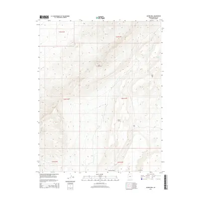
2014 Map of Jacobs Well
USGS Topo · Published 2014About this map
Virgin Mountains and the Mojave Desert converge in this high-elevation corner of Mohave County, where the topography is defined by significant vertical relief and dry drainage systems. Water sources are the critical landmarks in this arid environment, represented by the namesake Jacobs Well and Cottonwood Spring. The landscape is carved by seasonal watercourses like Tom and Cull Wash, which descends from the peaks, and Cottonwood Wash near the southern boundary. Significant elevations include Black Rock Mtn in the east, providing a clear picture of the land's rugged character. Human presence is sparse, limited primarily to the track of CR 101, leaving the focus on the natural geographic features and the Public Land Survey System township and range lines that grid this section of the Arizona strip.
Find a feature on this map
15 named features on this map. Tap any name to fly to it.
Don’t see what you’re looking for? This feature index may not catch every label — zoom into the map to look around manually.
Map Details
Editions of this 2014 Jacobs Well Map
This is the sole edition of this map. No revisions or reprints were ever made.
Other maps of this area

1886 · Saint Thomas
USGS Topo · 1:250,000

1886 · Mt. Trumbull
USGS Topo · 1:250,000

1892 · Mt. Trumbull
USGS Topo · 1:250,000

1893 · Saint Thomas
USGS Topo · 1:250,000

1953 · Grand Canyon
USGS Topo · 1:250,000

1954 · Las Vegas
USGS Topo · 1:250,000

1954 · Littlefield 3 SW
USGS Topo · 1:24,000

1954 · Littlefield 3 NE
USGS Topo · 1:24,000
1954 · Littlefield 3 SE
USGS Topo · 1:24,000

1954 · Littlefield
USGS Topo · 1:62,500