
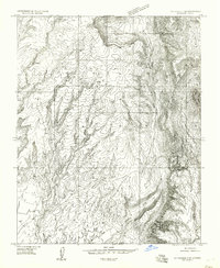
1954 Map of Littlefield 3 SW
USGS Topo · Published 1957About this map
Cove Spring serves as a vital water source in this arid corner of Mohave County, where the desert floor meets rising Mountains. Mapped by the Geological Survey in the mid-1950s using aerial photography, the landscape is defined by the deep incisions of Cottonwood Canyon and the winding course of Cottonwood Wash. The map documents a sparsely settled territory where the township boundary between T. 37 N. and T. 36 N. bisects the terrain. The presence of named water features like Tom Wash amidst the complex contouring indicates the importance of these drainages for navigation and survival in a region where the geology dictates the paths of travel. This preliminary edition captures the area before more standardized 15-minute maps were finalized, preserving the specific topographical details of the era.
Find a feature on this map
6 named features on this map. Tap any name to fly to it.
Don’t see what you’re looking for? This feature index may not catch every label — zoom into the map to look around manually.
Map Details
Editions of this 1954 Littlefield 3 SW Map
This is the sole edition of this map. No revisions or reprints were ever made.
Other maps of this area

1886 · Saint Thomas
USGS Topo · 1:250,000

1886 · Mt. Trumbull
USGS Topo · 1:250,000

1892 · Mt. Trumbull
USGS Topo · 1:250,000

1893 · Saint Thomas
USGS Topo · 1:250,000

1926 · Bonelli
USGS Topo · 1:96,000

1953 · Gold Butte
USGS Topo · 1:62,500

1953 · Grand Canyon
USGS Topo · 1:250,000

1954 · Las Vegas
USGS Topo · 1:250,000

1954 · Littlefield 3 NE
USGS Topo · 1:24,000
1954 · Littlefield 3 SE
USGS Topo · 1:24,000