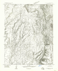
1954 Map of Littlefield 3 SE
USGS Topo · Published 1957About this map
Grand Wash cuts through this remote Mohave County landscape, which was documented in the mid-1950s using multiplex mapping methods. This preliminary edition shows a rugged high-desert terrain dominated by significant topographical formations like Pocum and Nutter. The map is characteristic of the arid Arizona borderlands, where water sources were critical for survival and land management; a single Water Trough is one of the few human-centric landmarks noted in the entire quadrangle. The lack of primary roads or developed townsites reflects the area's isolation during this era, serving primarily as open rangeland or wilderness. Surveyors noted the transition between townships T. 37 N. and T. 36 N., providing a rare 1:24,000 scale view of an area that was typically only available in broader 15-minute map series.
Find a feature on this map
6 named features on this map. Tap any name to fly to it.
Don’t see what you’re looking for? This feature index may not catch every label — zoom into the map to look around manually.
Map Details
Editions of this 1954 Littlefield 3 SE Map
This is the sole edition of this map. No revisions or reprints were ever made.
Other maps of this area

1886 · Mt. Trumbull
USGS Topo · 1:250,000

1892 · Mt. Trumbull
USGS Topo · 1:250,000

1953 · Grand Canyon
USGS Topo · 1:250,000

1954 · Littlefield 3 SW
USGS Topo · 1:24,000

1954 · Littlefield 3 NE
USGS Topo · 1:24,000

1954 · Cane Springs
USGS Topo · 1:62,500

1957 · Grand Canyon
USGS Topo · 1:250,000

1958 · Grand Canyon
USGS Topo · 1:250,000

1960 · Grand Canyon
USGS Topo · 1:250,000
1971 · Olaf Knolls
USGS Topo · 1:24,000