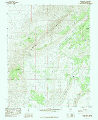
1985 Map of Jacobs Well
USGS Topo · Published 1985About this map
The Virgin Mountains dominate this high-desert landscape in northern Arizona, where the terrain is defined by dramatic elevation changes and essential water sources. Settlers and prospectors in this arid environment relied heavily on named points like Jacobs Well, Lead Mine Spring, and Cottonwood Spring. The nomenclature of the peaks—including Lead Mine Mountain, Tungsten Mountain, and Lime Kiln Mountain—strongly suggests an era of mineral extraction and resource processing that shaped the local economy and movement patterns.
Find a feature on this map
14 named features on this map. Tap any name to fly to it.
Don’t see what you’re looking for? This feature index may not catch every label — zoom into the map to look around manually.
Map Details
Editions of this 1985 Jacobs Well Map
This is the sole edition of this map. No revisions or reprints were ever made.
Other maps of this area

1886 · Saint Thomas
USGS Topo · 1:250,000

1886 · Mt. Trumbull
USGS Topo · 1:250,000

1892 · Mt. Trumbull
USGS Topo · 1:250,000

1893 · Saint Thomas
USGS Topo · 1:250,000

1953 · Grand Canyon
USGS Topo · 1:250,000

1954 · Las Vegas
USGS Topo · 1:250,000

1954 · Littlefield 3 SW
USGS Topo · 1:24,000

1954 · Littlefield 3 NE
USGS Topo · 1:24,000
1954 · Littlefield 3 SE
USGS Topo · 1:24,000

1954 · Littlefield
USGS Topo · 1:62,500