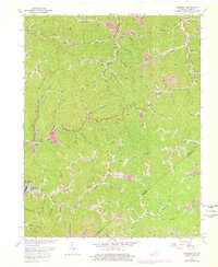
1963 Map of Jamboree
USGS Topo · Published 1978About this map
Jamboree and the rugged hollows of Pike County are defined by a complex network of creeks and coal-bearing ridges along the Kentucky and Virginia state line. The Norfolk and Western railway follows the winding path of Johns Creek and the Levisa Fork valley, serving as the industrial artery for small communities like Dunlap and Fedscreek. These settlements are closely tied to the timber and mining geography of the Appalachians, with evidence of early resource extraction visible in the numerous gas wells and a Strip Mine located near Horse Narrows Br.
Find a feature on this map
69 named features on this map. Tap any name to fly to it.
Don’t see what you’re looking for? This feature index may not catch every label — zoom into the map to look around manually.
Map Details
Editions of this 1963 Jamboree Map
2 editions found
Other maps of this area

1886 · Grundy
USGS Topo · 1:125,000

1887 · Warfield
USGS Topo · 1:125,000

1890 · Grundy
USGS Topo · 1:125,000

1891 · Warfield
USGS Topo · 1:125,000

1892 · Grundy
USGS Topo · 1:125,000

1909 · Matewan
USGS Topo · 1:48,000

1914 · Hurley
USGS Topo · 1:48,000

1915 · Regina
USGS Topo · 1:48,000

1915 · Hurley
USGS Topo · 1:48,000

1915 · Williamson
USGS Topo · 1:48,000