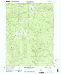
1966 Map of James City
USGS Topo · Published 1986About this map
The extraction of Pennsylvania's natural resources dominates the landscape of the Allegheny National Forest during the mid-1960s. Dense networks of Oil Wells and Gas Wells are scattered across the townships of Wetmore, Highland, and Jones, connected by service roads and the Baltimore and Ohio railroad line. Settlement is concentrated in small pockets like James City and Lamont, while much of the area is dedicated to resource management at the Kane Experimental Forest Headquarters.
Find a feature on this map
41 named features on this map. Tap any name to fly to it.
Don’t see what you’re looking for? This feature index may not catch every label — zoom into the map to look around manually.
Map Details
Editions of this 1966 James City Map
3 editions found
Other maps of this area

1934 · Kane
USGS Topo · 1:48,000

1935 · Mt. Jewett
USGS Topo · 1:48,000

1939 · Kane
USGS Topo · 1:62,500

1940 · Hallton
USGS Topo · 1:48,000

1940 · Mt. Jewett
USGS Topo · 1:62,500

1941 · Ridgway
USGS Topo · 1:62,500

1943 · Hallton
USGS Topo · 1:62,500

1944 · Ridgway
USGS Topo · 1:62,500

1957 · Warren
USGS Topo · 1:250,000

1958 · Warren
USGS Topo · 1:250,000
Featured Places
- Lamont, Jones Township
- Wetmore Township, PA
- Ridgway Township, PA
- Jones Township, PA
- Nansen, Highland Township