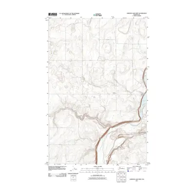
2011 Map of Jameson Lake West
USGS Topo · Published 2011About this map
Jameson Cemetery rests on a high bench overlooking the northern reaches of Jameson Lake, marking a point of quiet history in this corner of Douglas County. The landscape is defined by the dramatic coulee topography typical of the region, where McCartney Creek winds through the deep canyon floor before reaching the lake. Significant topographic depressions like Kester Draw and Dutch Henry Draw carve into the surrounding plateaus, creating a complex series of ridges and basins. The mapping of early 21st-century rural infrastructure follows a rigid section-line grid, represented by roads such as N Division Rd and Berg Rd NE. This network facilitates movement between the high rangeland and the water sources found at Stark Springs, reflecting the long-standing agricultural and ranching patterns that have shaped this terrain since its initial settlement.
Find a feature on this map
20 named features on this map. Tap any name to fly to it.
Don’t see what you’re looking for? This feature index may not catch every label — zoom into the map to look around manually.
Map Details
Editions of this 2011 Jameson Lake West Map
This is the sole edition of this map. No revisions or reprints were ever made.
Other maps of this area

1953 · Ritzville
USGS Topo · 1:250,000

1959 · Ritzville
USGS Topo · 1:250,000

1965 · Ritzville
USGS Topo · 1:250,000

1965 · Jameson Lake SW
USGS Topo · 1:24,000

1965 · Jameson Lake SE
USGS Topo · 1:24,000

1965 · Jameson Lake West
USGS Topo · 1:24,000

1965 · Jameson Lake East
USGS Topo · 1:24,000

1968 · Withrow
USGS Topo · 1:24,000
1968 · Mud Spring
USGS Topo · 1:24,000
1968 · Farmer
USGS Topo · 1:24,000