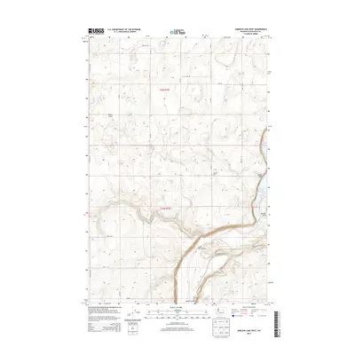
2014 Map of Jameson Lake West
USGS Topo · Published 2014About this map
Jameson Lake and the deep channel of the Moses Coulee define this arid landscape in northern Douglas County. The terrain is marked by dramatic coulees and draws, including Dutch Henry Draw and Kester Draw, which cut through the high plateau. The map details a rectilinear grid of rural roads, such as N Division Rd and Engle Rd NE, that service the local agricultural and ranching operations. The presence of Jameson Cem near the lake serves as a focal point for local family history in this sparsely populated region. Seasonal water features like McCartney Cr and Stark Springs highlight the importance of water management in the semi-arid environment of central Washington.
Find a feature on this map
23 named features on this map. Tap any name to fly to it.
Don’t see what you’re looking for? This feature index may not catch every label — zoom into the map to look around manually.
Map Details
Editions of this 2014 Jameson Lake West Map
This is the sole edition of this map. No revisions or reprints were ever made.
Other maps of this area

1953 · Ritzville
USGS Topo · 1:250,000

1959 · Ritzville
USGS Topo · 1:250,000

1965 · Ritzville
USGS Topo · 1:250,000

1965 · Jameson Lake SW
USGS Topo · 1:24,000

1965 · Jameson Lake SE
USGS Topo · 1:24,000

1965 · Jameson Lake West
USGS Topo · 1:24,000

1965 · Jameson Lake East
USGS Topo · 1:24,000

1968 · Withrow
USGS Topo · 1:24,000
1968 · Mud Spring
USGS Topo · 1:24,000
1968 · Farmer
USGS Topo · 1:24,000