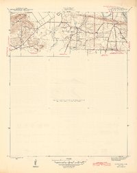
1942 Map of Jamestown
USGS Topo · Published 1945About this map
The White River winds through the northeast corner of this 1942 survey, framing Earnheart Island and the neighboring Simpson Slough. This landscape in Independence County is defined by the transition from the river bottomlands to the elevations of Dean Mtn and Slate Hill. Local life in the mid-1940s centered on several rural nodes, including the settlement of Locust Grove and the Allen Chapel community.
Find a feature on this map
23 named features on this map. Tap any name to fly to it.
Don’t see what you’re looking for? This feature index may not catch every label — zoom into the map to look around manually.
Map Details
Editions of this 1942 Jamestown Map
3 editions found
Other maps of this area

1890 · Batesville
USGS Topo · 1:125,000

1891 · Batesville
USGS Topo · 1:125,000

1942 · Bethesda
USGS Topo · 1:24,000

1942 · Jamestown
USGS Topo · 1:31,680

1942 · Almond
USGS Topo · 1:31,680

1942 · Salado
USGS Topo · 1:31,680

1942 · Batesville
USGS Topo · 1:31,680

1943 · Sulphur Rock
USGS Topo · 1:31,680

1943 · Batesville
USGS Topo · 1:24,000

1953 · Memphis
USGS Topo · 1:250,000