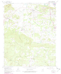
1965 Map of Jamestown
USGS Topo · Published 1982About this map
Old Indian Treaty Boundary slices across the northwestern corner of this landscape, marking a historical division between lands near Dean Mountain. To the east, the White River and Simpson Slough define a low-lying riparian zone where Earnheart Island and Luster Island sit near the growing fringes of Dennison Heights. The settlement of Desha and the Batesville Municipal Airport anchor the northern flats, while the terrain rises sharply to the south into the timbered heights of Jamestown Mountain and Hutchinson Mountain. Cultural landmarks for family historians include numerous small congregations and burial grounds, such as Palestine Cem, Jamestown Ch, and Alderbrook Cem. A network of hollows like Tivis Flynn Hollow and Ed Taylor Hollow carve through the central ridges, illustrating how the early road system followed the natural contours between these upland communities.
Find a feature on this map
59 named features on this map. Tap any name to fly to it.
Don’t see what you’re looking for? This feature index may not catch every label — zoom into the map to look around manually.
Map Details
Editions of this 1965 Jamestown Map
2 editions found
Other maps of this area

1890 · Batesville
USGS Topo · 1:125,000

1891 · Batesville
USGS Topo · 1:125,000

1942 · Bethesda
USGS Topo · 1:24,000

1942 · Jamestown
USGS Topo · 1:31,680

1942 · Almond
USGS Topo · 1:31,680

1942 · Salado
USGS Topo · 1:31,680

1942 · Batesville
USGS Topo · 1:31,680

1943 · Sulphur Rock
USGS Topo · 1:31,680

1943 · Batesville
USGS Topo · 1:24,000

1953 · Memphis
USGS Topo · 1:250,000