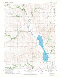
1968 Map of Jamestown NW
USGS Topo · Published 1971About this map
Jamestown State Waterfowl Management Area dominates this North-Central Kansas landscape, centered on the waters of Sportsmans Lake. The topography is defined by the convergence of several waterways, including Marsh Creek, Buffalo Creek, and Dry Creek, which cut through the agricultural townships of Grant, Courtland, and Vicksburg. This 1960s survey illustrates a region where water management and transportation were vital, showing two major rail lines: the Atchison Topeka and Santa Fe and the Missouri Pacific.
Find a feature on this map
22 named features on this map. Tap any name to fly to it.
Don’t see what you’re looking for? This feature index may not catch every label — zoom into the map to look around manually.
Map Details
Editions of this 1968 Jamestown NW Map
This is the sole edition of this map. No revisions or reprints were ever made.
Other maps of this area

1892 · Concordia
USGS Topo · 1:125,000

1894 · Mankato
USGS Topo · 1:125,000

1955 · Manhattan
USGS Topo · 1:250,000

1955 · Beloit
USGS Topo · 1:250,000

1956 · Manhattan
USGS Topo · 1:250,000

1957 · Manhattan
USGS Topo · 1:250,000

1959 · Beloit
USGS Topo · 1:250,000

1962 · Jewell SE
USGS Topo · 1:24,000

1965 · Kackley
USGS Topo · 1:24,000

1966 · Scandia
USGS Topo · 1:24,000