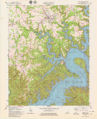
1978 Map of Jamestown
USGS Topo · Published 1979About this map
Lake Cumberland dominates this 1970s landscape, its controlled inundation having reshaped the rugged terrain of the Cumberland River valley. The map reveals the extensive recreational infrastructure developed around the shoreline, including the Lake Cumberland State Resort Park with its golf course, campground, and multiple facilities like the State Dock. The elevation of the water to 760 feet has created a complex network of inlets and peninsulas, such as Pig Pen Point and Lowgap Island, while former river features like the Bugwood Narrows now sit submerged or shoreline-adjacent.
Find a feature on this map
63 named features on this map. Tap any name to fly to it.
Don’t see what you’re looking for? This feature index may not catch every label — zoom into the map to look around manually.
Map Details
Editions of this 1978 Jamestown Map
This is the sole edition of this map. No revisions or reprints were ever made.
Other maps of this area

1911 · Monticello
USGS Topo · 1:62,500

1914 · Monticello
USGS Topo · 1:62,500

1953 · Montpelier
USGS Topo · 1:24,000

1953 · Parnell
USGS Topo · 1:24,000

1953 · Wolf Creek Dam
USGS Topo · 1:24,000

1953 · Creelsboro
USGS Topo · 1:24,000

1953 · Jamestown
USGS Topo · 1:24,000

1954 · Jabez
USGS Topo · 1:24,000

1954 · Cumberland City
USGS Topo · 1:24,000

1954 · Russell Springs
USGS Topo · 1:24,000