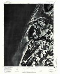
1977 Map of Jamesville
USGS Topo · Published 1982About this map
Jamesville and its surrounding agricultural fields occupy the fingers of land reaching into the Chesapeake Bay on Virginia's Eastern Shore. This orthophotographic study, based on imagery from late 1977, reveals a landscape defined by deep tidal inlets and waterfront access points. To the north, Davis Wharf sits at a critical junction along Occohannock Creek, reflecting the importance of maritime commerce and local landings in Northampton County. The settlement of Wardtown is situated inland, away from the immediate shoreline but connected to the network of roads serving the peninsula's farms. The southern portion of the map is dominated by the broad waters of Nassawadox Creek, while the northern boundary is marked by Nandua Creek. These waterways dictate the settlement patterns and field boundaries, showing a rural community deeply integrated with the Chesapeake's complex coastline.
Find a feature on this map
7 named features on this map. Tap any name to fly to it.
Don’t see what you’re looking for? This feature index may not catch every label — zoom into the map to look around manually.
Map Details
Editions of this 1977 Jamesville Map
This is the sole edition of this map. No revisions or reprints were ever made.
Other maps of this area

1942 · Nandua Creek
USGS Topo · 1:24,000

1942 · Nassawadox
USGS Topo · 1:24,000

1943 · Nassawadox
USGS Topo · 1:31,680

1943 · Jamesville
USGS Topo · 1:31,680

1943 · Pungoteague
USGS Topo · 1:31,680

1943 · Franktown
USGS Topo · 1:31,680

1943 · Exmore
USGS Topo · 1:24,000

1943 · Richmond
USGS Topo · 1:250,000

1944 · Exmore
USGS Topo · 1:31,680

1946 · Eastville
USGS Topo · 1:250,000