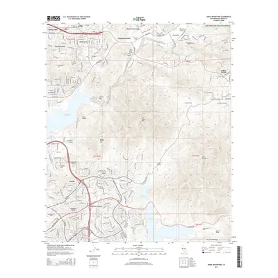
2015 Map of Jamul Mountains
USGS Topo · Published 2015About this map
San Miguel Mtn and Mother Miguel Mtn dominate the central topography of this San Diego County region, where urban expansion meets preserved open space. To the northwest, the residential communities of Spring Valley, Casa de Oro, and La Presa represent the edge of the metropolitan sprawl, while the San Diego Nat Wildlife Refuge protects the heights of the Jamul Mountains. Significant water management features are evident throughout the landscape, from the Sweetwater Reservoir in the west to Upper Otay Lake and Lower Otay Lake in the south. The development of master-planned communities is clearly visible at Eastlake and Eastlake Greens, situated near the institutional campus of Southwestern College. The infrastructure connecting these valleys is defined by the Second San Diego Aqueduct and major corridors like Otay Lakes Rd and Telegraph Canyon Rd, which navigate the complex terrain of Telegraph Canyon and Proctor Valley.
Find a feature on this map
58 named features on this map. Tap any name to fly to it.
Don’t see what you’re looking for? This feature index may not catch every label — zoom into the map to look around manually.
Map Details
Editions of this 2015 Jamul Mountains Map
This is the sole edition of this map. No revisions or reprints were ever made.
Other maps of this area

1893 · El Cajon
USGS Topo · 1:62,500

1901 · Elcajon
USGS Topo · 1:62,500

1903 · Cuyamaca
USGS Topo · 1:125,000

1903 · La Jolla
USGS Topo · 1:62,500

1903 · Elcajon
USGS Topo · 1:62,500

1904 · San Diego
USGS Topo · 1:62,500

1904 · Southern California Sheet No. 2
USGS Topo · 1:250,000

1930 · La Jolla
USGS Topo · 1:62,500

1930 · San Diego
USGS Topo · 1:62,500

1939 · El Cajon
USGS Topo · 1:62,500