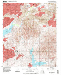
1994 Map of Jamul Mountains
USGS Topo · Published 1998About this map
Chula Vista and Spring Valley anchor this mid-1990s landscape, illustrating the rapid suburban expansion of San Diego County into the foothills of the Jamul Mountains. The map reveals a transition from established residential centers like Casa de Oro and La Presa to the emerging educational and athletic hubs of the era, including Cuyamaca College and the US Olympic Training Center situated along the banks of the Lower Otay Reservoir.
Find a feature on this map
57 named features on this map. Tap any name to fly to it.
Don’t see what you’re looking for? This feature index may not catch every label — zoom into the map to look around manually.
Map Details
Editions of this 1994 Jamul Mountains Map
This is the sole edition of this map. No revisions or reprints were ever made.
Other maps of this area

1893 · El Cajon
USGS Topo · 1:62,500

1901 · Elcajon
USGS Topo · 1:62,500

1903 · Cuyamaca
USGS Topo · 1:125,000

1903 · La Jolla
USGS Topo · 1:62,500

1903 · Elcajon
USGS Topo · 1:62,500

1904 · San Diego
USGS Topo · 1:62,500

1904 · Southern California Sheet No. 2
USGS Topo · 1:250,000

1930 · La Jolla
USGS Topo · 1:62,500

1930 · San Diego
USGS Topo · 1:62,500

1939 · El Cajon
USGS Topo · 1:62,500