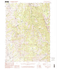
1986 Map of Jarbidge South
USGS Topo · Published 1987About this map
Jarbidge sits at the northern edge of this Elko County survey, serving as a gateway to the high-elevation mining and wilderness areas of the Humboldt National Forest. The map documents a significant history of extraction along the Jarbidge River, with numerous named sites such as the Altitude Mine, Pavlak Mine, and Elcoro Mine appearing alongside various unnamed shafts and adits. These workings are clustered near steep drainages like Bonanza Gulch and Snowslide Gulch, illustrating the difficult terrain encountered by prospectors in the Jarbidge Mountains. To the south, the landscape shifts toward the preserved lands of the Jarbidge Wilderness, where the headwaters of the Marys River and Fox Creek originate. High-altitude landmarks like Jarbidge Peak, Coon Creek Peak, and the Jack Creek Crater dominate the skyline, while established routes like Telephone Canyon and various pack trails provide the primary access through this remote portion of northeastern Nevada.
Find a feature on this map
48 named features on this map. Tap any name to fly to it.
Don’t see what you’re looking for? This feature index may not catch every label — zoom into the map to look around manually.
Map Details
Editions of this 1986 Jarbidge South Map
2 editions found
Other maps of this area

1935 · Charleston
USGS Topo · 1:48,000

1936 · Rowland
USGS Topo · 1:48,000

1940 · Rowland
USGS Topo · 1:62,500

1942 · Mt. Velma
USGS Topo · 1:62,500

1943 · Jarbidge
USGS Topo · 1:62,500

1945 · Jarbidge
USGS Topo · 1:62,500

1955 · Wells
USGS Topo · 1:250,000

1958 · Wells
USGS Topo · 1:250,000

1961 · Wells
USGS Topo · 1:250,000

1968 · Marys River Basin NE
USGS Topo · 1:24,000