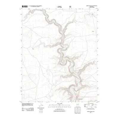
2011 Map of Jaritas Ranch
USGS Topo · Published 2011About this map
Canadian River canyonlands define this portion of Colfax County, where the river carves a deep, winding path through the high plains of northeastern New Mexico. This 2011 survey documents the remote ranching landscape of the Jaritas Ranch and the expansive protected reaches of the Kiowa National Grassland in the southeast corner. The terrain is marked by sharp relief where various drainages, such as Jaritas Arroyo and Ocate Creek, feed into the central river system. Local landmarks including California 1 Floersheim and a series of named side canyons like Dog Canyon and Pup Canyon provide a detailed look at the geographic naming conventions and land divisions of the area. Researchers can trace the intersection of water resources and ranch boundaries along the steep topography of Lodge Canyon and Early Canyon, illustrating the relationship between the river’s course and the high-desert cattle country.
Find a feature on this map
12 named features on this map. Tap any name to fly to it.
Don’t see what you’re looking for? This feature index may not catch every label — zoom into the map to look around manually.
Map Details
Editions of this 2011 Jaritas Ranch Map
This is the sole edition of this map. No revisions or reprints were ever made.
Other maps of this area

1954 · Raton
USGS Topo · 1:250,000

1958 · Raton
USGS Topo · 1:250,000

1964 · Stony Lake
USGS Topo · 1:24,000

1964 · Alto De Hormiga
USGS Topo · 1:24,000

1965 · Taylor Springs
USGS Topo · 1:24,000

1965 · Abbott
USGS Topo · 1:24,000

1965 · Springer
USGS Topo · 1:24,000

1971 · Abbott Lake
USGS Topo · 1:24,000

1972 · Canon Colorado
USGS Topo · 1:24,000
1972 · Jaritas Ranch
USGS Topo · 1:24,000