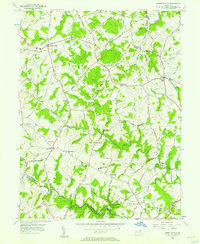
1956 Map of Jarrettsville
USGS Topo · Published 1957About this map
Jarrettsville and its surrounding rural hamlets are centered in a landscape of rolling agricultural land and winding stream valleys in mid-1950s Harford County. The map documents a dense network of small communities such as Coopstown, Sharon, and Pleasantville, many defined by local institutions like Old Brick Ch and Providence Ch. The Pennsylvania railroad cuts through the eastern portion of the area near Forest Hill, connecting this farming region to broader markets. In the south, the terrain descends toward the Little Gunpowder Falls, which forms the boundary with Baltimore County. Local educational and civic life is anchored by landmarks like the Youths Benefit School and the State Police Barracks near Benson. This survey preserves the exact locations of numerous family and church burial grounds, including the Johnson Cem and Macton Cem, providing essential details for genealogical research in this Maryland piedmont area.
Find a feature on this map
112 named features on this map. Tap any name to fly to it.
Don’t see what you’re looking for? This feature index may not catch every label — zoom into the map to look around manually.
Map Details
Editions of this 1956 Jarrettsville Map
4 editions found
Other maps of this area

1893 · Gunpowder
USGS Topo · 1:62,500

1894 · Baltimore
USGS Topo · 1:62,500

1898 · Tolchester
USGS Topo · 1:125,000

1899 · Baltimore
USGS Topo · 1:62,500

1900 · Parkton
USGS Topo · 1:62,500

1901 · Belair
USGS Topo · 1:62,500

1901 · Gunpowder
USGS Topo · 1:62,500

1902 · Parkton
USGS Topo · 1:62,500

1903 · Tolchester
USGS Topo · 1:125,000

1904 · Baltimore
USGS Topo · 1:62,500