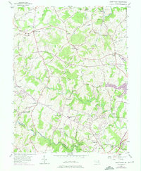
1956 Map of Jarrettsville
USGS Topo · Published 1975About this map
Jarrettsville and its neighboring Harford County hamlets are depicted during a period of transition as the rural landscape began to see modern developments. The corridor of the Maryland and Pennsylvania Railroad remains a prominent feature, tracing the path of the "Ma and Pa" line through the undulating countryside past Sharon and Forest Hill. This survey highlights a dense network of local landmarks essential for genealogical research, including numerous country churches like Watters Church and St Marks Church, as well as distinct burial grounds such as the Old Brick Church Cemetery and Moores Cemetery. The terrain is defined by the drainage of Little Gunpowder Falls and Winters Run, with the presence of a Landing Strip near Fallston and the Bel Air Reservoir signaling the evolving infrastructure of the mid-20th century in this portion of the Maryland Piedmont.
Find a feature on this map
89 named features on this map. Tap any name to fly to it.
Don’t see what you’re looking for? This feature index may not catch every label — zoom into the map to look around manually.
Map Details
Editions of this 1956 Jarrettsville Map
4 editions found
Other maps of this area

1893 · Gunpowder
USGS Topo · 1:62,500

1894 · Baltimore
USGS Topo · 1:62,500

1898 · Tolchester
USGS Topo · 1:125,000

1899 · Baltimore
USGS Topo · 1:62,500

1900 · Parkton
USGS Topo · 1:62,500

1901 · Belair
USGS Topo · 1:62,500

1901 · Gunpowder
USGS Topo · 1:62,500

1902 · Parkton
USGS Topo · 1:62,500

1903 · Tolchester
USGS Topo · 1:125,000

1904 · Baltimore
USGS Topo · 1:62,500