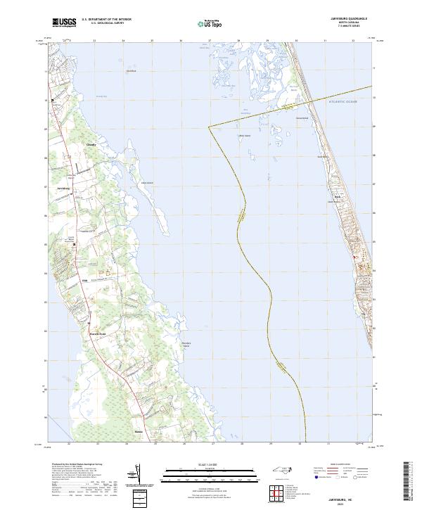
2023 Map of Jarvisburg
USGS Topo · Published 2023About this map
Jarvisburg and the surrounding coastal corridor of Currituck County sit at the heart of this recent survey, showcasing the narrow peninsula between the sound and the Atlantic Ocean. The settlement pattern follows the central roadway, connecting small communities like Grandy, Olds, and Powells Point. This landscape is defined by its relationship with the water, where marshy outlets like Tar Cove Marsh and various leads and bays segment the coast. On the western shore, the Cotton Gin Airport serves as a notable local landmark near Jarvisburg, while the eastern side of the map captures the residential expansion along the Outer Banks in Duck. Genealogy and local history are anchored by sites such as the Barco Family Cem and Corinth Baptist Church Cem, which offer a sense of the area's long-standing community roots amidst a modernizing coastal environment.
Find a feature on this map
77 named features on this map. Tap any name to fly to it.
Don’t see what you’re looking for? This feature index may not catch every label — zoom into the map to look around manually.
Map Details
Editions of this 2023 Jarvisburg Map
This is the sole edition of this map. No revisions or reprints were ever made.
Other maps of this area

1940 · Barco
USGS Topo · 1:62,500

1940 · Kitty Hawk
USGS Topo · 1:62,500

1940 · Powells Point
USGS Topo · 1:62,500

1946 · Eastville
USGS Topo · 1:250,000

1946 · Currituck Sound
USGS Topo · 1:250,000

1961 · Eastville
USGS Topo · 1:250,000

1966 · Eastville
USGS Topo · 1:250,000
1982 · Jarvisburg
USGS Topo · 1:24,000
1982 · Kitty Hawk
USGS Topo · 1:24,000
1982 · Point Harbor
USGS Topo · 1:24,000