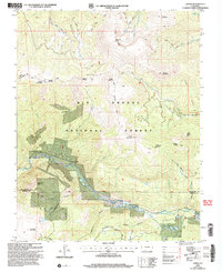
2001 Map of Jasper
USGS Topo · Published 2005About this map
Alamosa River drainage and the small settlement of Jasper define this high-altitude section of the Rio Grande National Forest at the turn of the 21st century. The map captures a landscape shaped by mining history and early forest management, where a legacy Mine and a Ranger Station sit near the steep slopes of Cornwall Mountain. The hydrology of the region is notably complex, featuring high-country water bodies like the San Francisco Lakes and Silver Lakes, alongside a dense network of gulches including California Gulch and Rhodes Gulch. A primitive transportation network of trails, such as the Fitton Trail and Ranger Trail, provides the primary access through the high passes like Blowout Pass. This survey illustrates the rugged interface between the Rio Grande and Conejos county line, where natural landmarks like Cornwalls Nose serve as prominent navigational markers for those tracing historical land use and early resource extraction.
Find a feature on this map
45 named features on this map. Tap any name to fly to it.
Don’t see what you’re looking for? This feature index may not catch every label — zoom into the map to look around manually.
Map Details
Editions of this 2001 Jasper Map
This is the sole edition of this map. No revisions or reprints were ever made.
Other maps of this area

1913 · Summitville
USGS Topo · 1:125,000

1914 · Creede
USGS Topo · 1:125,000

1915 · Summitville
USGS Topo · 1:125,000

1915 · Del Norte
USGS Topo · 1:125,000

1916 · Creede
USGS Topo · 1:125,000

1917 · Del Norte
USGS Topo · 1:125,000

1922 · Conejos
USGS Topo · 1:125,000

1945 · Durango
USGS Topo · 1:250,000

1953 · Durango
USGS Topo · 1:250,000

1954 · Durango
USGS Topo · 1:250,000