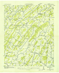
1935 Map of Jearoldstown
USGS Topo · Published 1935About this map
Jearoldstown serves as the focal point for this 1935 study of the high ridges and intricate valleys of the Greene and Washington county line. The landscape is defined by long, parallel elevations like Kyle Bone Ridge and Hayes Ridge, which dictated the early settlement patterns of rural East Tennessee. Numerous small communities and family-named landmarks are visible, including Milburton, Liberty Hill, and Ducktown, each anchored by local institutions such as Bethesda Ch or Indian Grove Sch.
Find a feature on this map
76 named features on this map. Tap any name to fly to it.
Don’t see what you’re looking for? This feature index may not catch every label — zoom into the map to look around manually.
Map Details
Editions of this 1935 Jearoldstown Map
This is the sole edition of this map. No revisions or reprints were ever made.
Other maps of this area

1892 · Greeneville
USGS Topo · 1:125,000

1896 · Greeneville
USGS Topo · 1:125,000

1904 · Greeneville
USGS Topo · 1:125,000

1935 · Surgoinsville
USGS Topo · 1:48,000

1935 · Baileyton
USGS Topo · 1:24,000

1935 · Lovelace
USGS Topo · 1:24,000

1935 · Sullivan Gardens
USGS Topo · 1:24,000

1935 · Leesburg
USGS Topo · 1:24,000
1935 · Stonypoint
USGS Topo · 1:24,000

1935 · Fall Branch
USGS Topo · 1:48,000