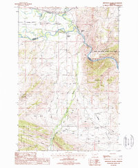
1987 Map of Jefferson Island
USGS Topo · Published 1988About this map
The Jefferson River winds through this Montana landscape, forming the boundary between Jefferson and Madison counties and supporting a network of agriculture and transport in the late 1980s. The Burlington Northern railroad follows the river's path, connecting the small settlements of Cardwell and Jefferson Island. This area is defined by the sharp transition from the fertile river bottoms near Boulder Slough to the steep, rising elevations of the London Hills and the Deerlodge National Forest.
Find a feature on this map
32 named features on this map. Tap any name to fly to it.
Don’t see what you’re looking for? This feature index may not catch every label — zoom into the map to look around manually.
Map Details
Editions of this 1987 Jefferson Island Map
This is the sole edition of this map. No revisions or reprints were ever made.
Other maps of this area

1888 · Three Forks
USGS Topo · 1:250,000

1893 · Dillon
USGS Topo · 1:250,000

1894 · Three Forks
USGS Topo · 1:250,000

1895 · Three Forks
USGS Topo · 1:250,000

1947 · Bozeman
USGS Topo · 1:250,000

1948 · Bozeman
USGS Topo · 1:250,000

1950 · Jefferson Island
USGS Topo · 1:62,500

1950 · Harrison
USGS Topo · 1:62,500

1955 · Bozeman
USGS Topo · 1:250,000

1955 · Dillon
USGS Topo · 1:250,000