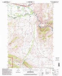
1996 Map of Jefferson Island
USGS Topo · Published 1998About this map
Jefferson River currents define the northern boundary of this landscape, where the waterway meanders past Cardwell and the namesake Jefferson Island. The area is a complex intersection of river-bottom lowlands and significant uplands like the London Hills and Summit Valley. Human activity is marked by a mix of recreation and extraction, from the subterranean passages of Lewis and Clark Cavern State Park to the industrial legacy of the Mayflower Mine and various prospects scattered across the hills.
Find a feature on this map
23 named features on this map. Tap any name to fly to it.
Don’t see what you’re looking for? This feature index may not catch every label — zoom into the map to look around manually.
Map Details
Editions of this 1996 Jefferson Island Map
This is the sole edition of this map. No revisions or reprints were ever made.
Other maps of this area

1888 · Three Forks
USGS Topo · 1:250,000

1893 · Dillon
USGS Topo · 1:250,000

1894 · Three Forks
USGS Topo · 1:250,000

1895 · Three Forks
USGS Topo · 1:250,000

1947 · Bozeman
USGS Topo · 1:250,000

1948 · Bozeman
USGS Topo · 1:250,000

1950 · Jefferson Island
USGS Topo · 1:62,500

1950 · Harrison
USGS Topo · 1:62,500

1955 · Bozeman
USGS Topo · 1:250,000

1955 · Dillon
USGS Topo · 1:250,000