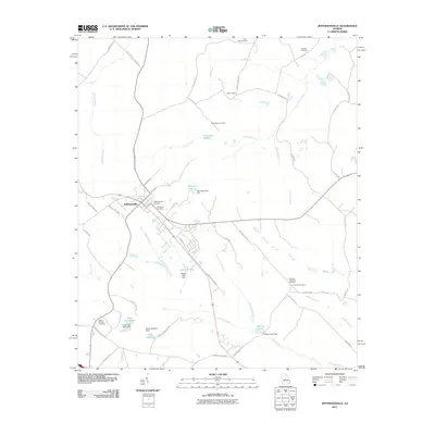
2011 Map of Jeffersonville
USGS Topo · Published 2011About this map
Jeffersonville serves as the central hub of this 2011 survey, where the intersection of state highways and local roads like Railroad St E and E Magnolia St defines the town's geography. The surrounding Twiggs County landscape is heavily marked by family-named landmarks and private burial grounds, including the Wimberly Cemetery and Jeffersonville Cemetery. The map reveals a high concentration of small, dammed water bodies and creeks that drainage systems like Turkey Creek and Alligator Creek feed into. Notable examples include Hamrick Lake, McCallum Pond, and the paired Faulk Lake West and Faulk Lake East. This network of ponds and minor branches, such as Pennywinkle Branch and Beaver Branch, suggests a landscape primarily dedicated to local agricultural or recreational use, connected by a dense web of rural routes like Gallimore Mill Rd and Durham Mill Rd.
Find a feature on this map
59 named features on this map. Tap any name to fly to it.
Don’t see what you’re looking for? This feature index may not catch every label — zoom into the map to look around manually.
Map Details
Editions of this 2011 Jeffersonville Map
This is the sole edition of this map. No revisions or reprints were ever made.
Other maps of this area

1916 · Irwinton
USGS Topo · 1:62,500

1920 · Irwinton
USGS Topo · 1:62,500

1956 · Gordon
USGS Topo · 1:62,500

1956 · Jeffersonville
USGS Topo · 1:62,500

1957 · Macon
USGS Topo · 1:250,000

1958 · Macon
USGS Topo · 1:250,000

1964 · Macon
USGS Topo · 1:250,000

1973 · Massey Hill
USGS Topo · 1:24,000
1973 · Irwinton
USGS Topo · 1:24,000

1973 · Tarversville
USGS Topo · 1:24,000