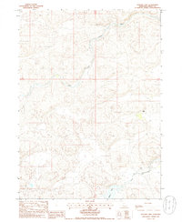
1985 Map of Jefford Lake
USGS Topo · Published 1986About this map
The North Fork Dismal River and South Fork Dismal River dominate this mid-1980s topographical study of the Nebraska Sandhills. The landscape is characterized by its drainage patterns, where the narrow waterways and the prominent Jefford Lake provide essential resources for local ranching operations. Human presence is sparse but clearly defined by family-named landholdings such as the Gragg Ranch and J Tucker Ranch. Connectivity across this terrain relies heavily on 4wd trails that navigate the shifting topography between the forks of the river. A small Cem near the river banks serves as a quiet marker of the area's genealogical history, while the northern reach of the map is defined by the winding course of Bobtail Cr as it feeds into the river system.
Find a feature on this map
10 named features on this map. Tap any name to fly to it.
Don’t see what you’re looking for? This feature index may not catch every label — zoom into the map to look around manually.
Map Details
Editions of this 1985 Jefford Lake Map
This is the sole edition of this map. No revisions or reprints were ever made.
Other maps of this area

1947 · Dismal River Ranch
USGS Topo · 1:62,500

1948 · Carr Lake
USGS Topo · 1:62,500

1949 · Dismal River Ranch
USGS Topo · 1:62,500

1949 · Flats
USGS Topo · 1:62,500

1949 · Wright Valley
USGS Topo · 1:62,500

1950 · Flats
USGS Topo · 1:62,500

1950 · Carr Lake
USGS Topo · 1:62,500

1951 · Wright Valley
USGS Topo · 1:62,500

1954 · North Platte
USGS Topo · 1:250,000

1956 · North Platte
USGS Topo · 1:250,000