1954 Map of North Platte
USGS Topo · Published 1968About this map
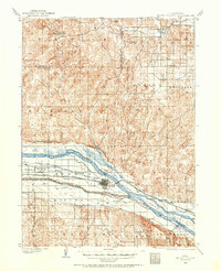
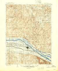
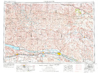
Lake C W Mcconaughy and the North Platte River dominate the southern landscape of this 1950s era survey, illustrating a massive irrigation and power network. The Sutherland Canal and Tri-County Canal link the reservoirs, feeding into the Sutherland Reservoir and Lake Maloney near North Platte. North of the river valley, the topography shifts abruptly into the rolling Sand Hills, a region defined by intricate valley systems like Cherry Valley and Snyder Valley. The map reveals a high density of rural infrastructure, including numerous family-named landmarks like Packard Ranch and a network of district schools such as Rosebud School and Madron School. The Nebraska National Forest stands as a distinct green preserve near Halsey, while the Union Pacific railroad tracks provide the primary transit corridor through the Platte Valley, connecting river towns from Brule to Maxwell.
Find a feature on this map
178 named features on this map. Tap any name to fly to it.
Don’t see what you’re looking for? This feature index may not catch every label — zoom into the map to look around manually.
Map Details
Editions of this 1954 North Platte Map
3 editions found
Historical Maps of North Platte Through Time
7 maps found