1896 Map of Lexington
USGS Topo · Published 1896About this map
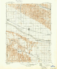
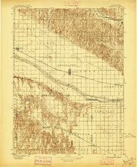
The Platte River corridor serves as the central artery for this late 19th-century survey, revealing a landscape defined by the arrival of the great railroads. The Union Pacific R. R. (Main Line) dictates the placement of thriving trackside settlements like Lexington, Cozad, and Overton. These early prairie towns are connected across the wide river valley by the Lexington Bridge and Overton Bridge. To the south, the Burlington and Missouri River R. R. (Cheyenne Line) carves its own path through Elwood and Smithfield, while the northern hills are home to Sumner along the Kearney and Black Hills Line. The map provides a remarkable view of the region before modern irrigation and highways, showing the original surveyor townships and the early importance of water sources such as Plum Creek and Wood River.
Find a feature on this map
51 named features on this map. Tap any name to fly to it.
Don’t see what you’re looking for? This feature index may not catch every label — zoom into the map to look around manually.
Map Details
Editions of this 1896 Lexington Map
This is the sole edition of this map. No revisions or reprints were ever made.