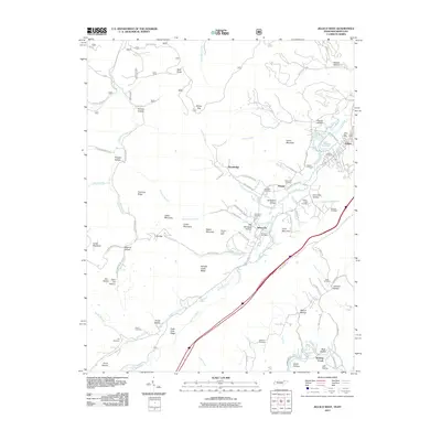
2011 Map of Jellico West
USGS Topo · Published 2011About this map
Jellico and the surrounding borderlands of Campbell County, Tennessee, and Whitley County, Kentucky, are defined by a complex network of hollows and ridges shaped by the coal and timber industries. This 2011 survey illustrates the concentrated settlement patterns along Elk Creek and Whistle Creek, where the Whistle Creek Mine and the Newcomb Post Office anchor local geography. The map reveals the historical depth of these mountain communities through an extensive collection of family and community burial grounds, including the Beard Cemetery, Jellico Cemetery, and the curiously named Hoot Owl Cemetery.
Find a feature on this map
86 named features on this map. Tap any name to fly to it.
Don’t see what you’re looking for? This feature index may not catch every label — zoom into the map to look around manually.
Map Details
Editions of this 2011 Jellico West Map
This is the sole edition of this map. No revisions or reprints were ever made.
Other maps of this area

1890 · Williamsburg
USGS Topo · 1:125,000

1893 · Briceville
USGS Topo · 1:125,000

1894 · Williamsburg
USGS Topo · 1:125,000

1895 · Briceville
USGS Topo · 1:125,000

1896 · Briceville
USGS Topo · 1:125,000

1936 · Ivydell
USGS Topo · 1:24,000

1936 · Pioneer
USGS Topo · 1:24,000

1936 · La Follette
USGS Topo · 1:48,000
1936 · La Follette
USGS Topo · 1:24,000
1946 · Ivydell
USGS Topo · 1:24,000