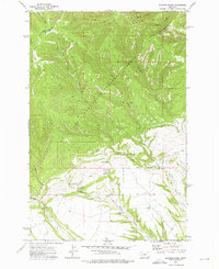
1972 Map of Jellison Place
USGS Topo · Published 1976About this map
The Lewis and Clark National Forest boundary marks a sharp transition between the wooded, canyon-carved highlands and the spring-fed rangelands of the Judith Basin. The Judith Basin and Wheatland County line traverses the northern section of the map, cutting through Sawmill Canyon and Dark Canyon. This landscape is defined by its water management, evidenced by the presence of Jellison Reservoir and the Middle Fork Reservoir situated among a network of natural water sources like Muir Spring and Forks Spring. The namesake Jellison Place sits at the base of the forest slopes where the terrain levels out into the Middle Fork and Hopley Creek drainages. The distribution of numerous wells and named springs suggests a landscape where water was the primary driver of habitation and livestock management during the early 1970s.
Find a feature on this map
21 named features on this map. Tap any name to fly to it.
Don’t see what you’re looking for? This feature index may not catch every label — zoom into the map to look around manually.
Map Details
Editions of this 1972 Jellison Place Map
This is the sole edition of this map. No revisions or reprints were ever made.
Other maps of this area

1886 · Little Belt Mts.
USGS Topo · 1:250,000

1889 · Big Snowy Mountain
USGS Topo · 1:250,000

1893 · Big Snowy Mountain
USGS Topo · 1:250,000

1894 · Little Belt Mts.
USGS Topo · 1:250,000

1897 · Little Belt Mts.
USGS Topo · 1:250,000

1898 · Little Belt Mts.
USGS Topo · 1:250,000

1902 · Little Belt Mts.
USGS Topo · 1:250,000

1948 · White Sulphur Springs
USGS Topo · 1:250,000

1954 · Roundup
USGS Topo · 1:250,000

1958 · Roundup
USGS Topo · 1:250,000