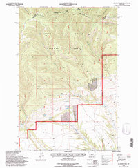
1995 Map of Jellison Place
USGS Topo · Published 1997About this map
Jellison Place sits at the heart of this landscape in the mid-1990s, where the high terrain of the Little Belt Mountains meets the headwaters of the Hopley Creek drainage. This survey, updated from earlier aerial photography, highlights a remote ranching and forest environment within the Lewis and Clark National Forest. The map documents a complex water system vital to the region's land use, featuring named water sources like Boecher Spring, Hopley Spring, and Muir Spring, alongside the Jellison Reservoir.
Find a feature on this map
27 named features on this map. Tap any name to fly to it.
Don’t see what you’re looking for? This feature index may not catch every label — zoom into the map to look around manually.
Map Details
Editions of this 1995 Jellison Place Map
This is the sole edition of this map. No revisions or reprints were ever made.
Other maps of this area

1886 · Little Belt Mts.
USGS Topo · 1:250,000

1889 · Big Snowy Mountain
USGS Topo · 1:250,000

1893 · Big Snowy Mountain
USGS Topo · 1:250,000

1894 · Little Belt Mts.
USGS Topo · 1:250,000

1897 · Little Belt Mts.
USGS Topo · 1:250,000

1898 · Little Belt Mts.
USGS Topo · 1:250,000

1902 · Little Belt Mts.
USGS Topo · 1:250,000

1948 · White Sulphur Springs
USGS Topo · 1:250,000

1954 · Roundup
USGS Topo · 1:250,000

1958 · Roundup
USGS Topo · 1:250,000