
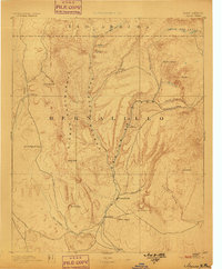
1890 Map of Jemes
USGS Topo · Published 1890About this map
Jemes Pueblo and the surrounding high desert mesas of what was then northern Bernalillo County are documented in this 1880s survey led by J.W. Powell. The landscape is dominated by the massive Sierra Nacimiento and deep geological cuts such as Canon de San Diego and Canon Guadalupe. Early industry is marked by the San Miguel Mine near the banks of the Rio Puerco, while seasonal waters and springs like Sulphur Springs and Ojo del Espiritu Santo appear as vital landmarks. The map traces the traditional footprints of San Ysidro, Archuleta, and Silla, showing the relationship between these early New Mexico settlements and the branching waters of Jemes Creek. Topography is detailed at 100-foot intervals, revealing the complex ridges of Sierrita Mesa and the volcanic heights of Pelado.
Find a feature on this map
30 named features on this map. Tap any name to fly to it.
Don’t see what you’re looking for? This feature index may not catch every label — zoom into the map to look around manually.
Map Details
Editions of this 1890 Jemes Map
2 editions found
Other maps of this area

1883 · Mt. Taylor
USGS Topo · 1:250,000

1886 · Mt. Taylor
USGS Topo · 1:250,000

1888 · Bernalillo
USGS Topo · 1:125,000

1889 · Albuquerque
USGS Topo · 1:125,000

1889 · Largo
USGS Topo · 1:250,000

1892 · San Pedro
USGS Topo · 1:125,000

1892 · Jemes
USGS Topo · 1:125,000

1892 · Santa Clara
USGS Topo · 1:125,000

1892 · Mt. Taylor
USGS Topo · 1:250,000

1893 · Albuquerque
USGS Topo · 1:125,000