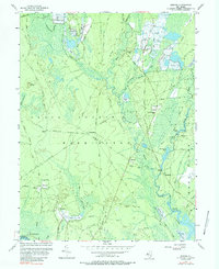
1956 Map of Jenkins
USGS Topo · Published 1988About this map
Cranberry Bogs and the intricate hydrology of the Pine Barrens dominate this mid-century landscape. The map details the complex water network of the West Branch Wading River and Oswego River, where agricultural operations like the Hog Wallow Cranberry Bogs were integrated into the swampy terrain. Small, rural settlements such as Friendship, Maxwell, and Jenkins are connected by a web of sand and gravel roads, including the Speedwell Road and Washington Road. Evidence of earlier industrial activity is visible through the Ruins Harrisville and the Washington Ruin, highlighting the area's transition from 19th-century resource extraction toward the conservation found in the Wharton State Forest. For genealogists, the map locates family-named spots like Bulltown, Tylertown, and Crowleytown, alongside local landmarks like St Andrews Ch and the Charcoal Landing on the riverbank.
Find a feature on this map
67 named features on this map. Tap any name to fly to it.
Don’t see what you’re looking for? This feature index may not catch every label — zoom into the map to look around manually.
Map Details
Editions of this 1956 Jenkins Map
3 editions found
Other maps of this area

1884 · Whitings
USGS Topo · 1:62,500

1888 · Pemberton
USGS Topo · 1:62,500

1888 · Little Egg Harbor
USGS Topo · 1:62,500

1888 · Whitings
USGS Topo · 1:62,500

1890 · Mullica
USGS Topo · 1:62,500

1893 · Little Egg Harbor
USGS Topo · 1:62,500

1894 · Pemberton
USGS Topo · 1:62,500

1894 · Mullica
USGS Topo · 1:62,500

1898 · Pemberton
USGS Topo · 1:62,500

1898 · Mullica
USGS Topo · 1:62,500
Featured Places
- Tabernacle Township, NJ
- Mullica Township, NJ
- Bass River Township, NJ
- Washington Township, NJ
- Crowleytown, Washington Township