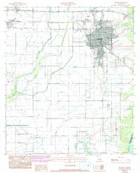
1985 Map of Jennings
USGS Topo · Published 1993About this map
Jennings serves as the focal point of this southwestern Louisiana landscape, where the grid of the town meets a complex system of water management and petroleum extraction. By the early 1990s, the urban footprint had expanded significantly, as shown by revisions tracking new residential developments and a Trailer Park north of the center. To the west, the village of Roanoke sits along the rail line, while the southern reaches are dominated by the Lake Arthur Oil and Gas Field, marked by a network of pipelines and a Pumping Station near the Mermentau River. The natural geography is defined by the winding paths of Grand Marais and its various branches, including West Bayou Grand Marais and East Bayou Grand Marais, which have been adapted over time with a system of siphons, flumes, and ditches to support the region's agricultural and industrial needs.
Find a feature on this map
22 named features on this map. Tap any name to fly to it.
Don’t see what you’re looking for? This feature index may not catch every label — zoom into the map to look around manually.
Map Details
Editions of this 1985 Jennings Map
2 editions found
Other maps of this area

1946 · Lake Arthur
USGS Topo · 1:31,680

1946 · Mermentau
USGS Topo · 1:31,680

1946 · Jennings
USGS Topo · 1:31,680

1947 · Evangeline
USGS Topo · 1:31,680

1947 · Thornwell
USGS Topo · 1:31,680

1947 · Pine Island
USGS Topo · 1:31,680

1947 · Welsh
USGS Topo · 1:31,680

1947 · Hathaway
USGS Topo · 1:31,680

1949 · Gueydan
USGS Topo · 1:31,680

1952 · Lake Charles
USGS Topo · 1:250,000