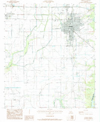
1985 Map of Jennings
USGS Topo · Published 1985About this map
The city of Jennings serves as a dense urban anchor in this mid-1980s landscape, characterized by a complex network of drainage ditches and bayous typical of the Louisiana prairie. To the west, the smaller settlement of Roanoke sits along the rail line, while the southern portion of the quadrangle is dominated by the Lake Arthur Oil and Gas Field, indicating the region's industrial reliance on petroleum extraction. The natural drainage of the land is defined by the winding paths of Grand Marais, West Bayou, and Middle Bayou, which eventually feed toward the Mermentau River on the eastern boundary. Notable local infrastructure such as the Municipal Airport and various Cem sites provide touchpoints for genealogists and local historians studying the growth of Jefferson Davis Parish during this era of agricultural and energy production.
Find a feature on this map
16 named features on this map. Tap any name to fly to it.
Don’t see what you’re looking for? This feature index may not catch every label — zoom into the map to look around manually.
Map Details
Editions of this 1985 Jennings Map
2 editions found
Other maps of this area

1946 · Lake Arthur
USGS Topo · 1:31,680

1946 · Mermentau
USGS Topo · 1:31,680

1946 · Jennings
USGS Topo · 1:31,680

1947 · Evangeline
USGS Topo · 1:31,680

1947 · Thornwell
USGS Topo · 1:31,680

1947 · Pine Island
USGS Topo · 1:31,680

1947 · Welsh
USGS Topo · 1:31,680

1947 · Hathaway
USGS Topo · 1:31,680

1949 · Gueydan
USGS Topo · 1:31,680

1952 · Lake Charles
USGS Topo · 1:250,000