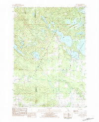
1983 Map of Jennings
USGS Topo · Published 1984About this map
Jennings serves as the focal point of this northern Michigan landscape, positioned within the Pere Marquette State Forest near the Wexford and Missaukee county line. The settlement's history is anchored by the Old Jennings Cem and New Jennings Cem, reflecting the community's longevity in this timber-rich region. The Lake City Railway cuts through the western portion of the quadrangle, illustrating the industrial transport network required for the area's resource extraction and commerce during the early 1980s.
Find a feature on this map
45 named features on this map. Tap any name to fly to it.
Don’t see what you’re looking for? This feature index may not catch every label — zoom into the map to look around manually.
Map Details
Editions of this 1983 Jennings Map
This is the sole edition of this map. No revisions or reprints were ever made.
Other maps of this area

1954 · Traverse City
USGS Topo · 1:250,000

1956 · Cadillac North
USGS Topo · 1:62,500

1956 · Lake City
USGS Topo · 1:62,500

1957 · Cadillac South
USGS Topo · 1:62,500

1957 · Marion
USGS Topo · 1:62,500

1958 · Traverse City
USGS Topo · 1:250,000

1983 · Cadillac
USGS Topo · 1:100,000

1983 · Lake City
USGS Topo · 1:25,000

1983 · Manton
USGS Topo · 1:25,000

1983 · Cadillac North
USGS Topo · 1:24,000