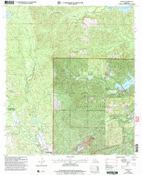
2003 Map of Jericho
USGS Topo · Published 2005About this map
The settlement of Jericho and the crossroads at Clifton anchor this central Louisiana landscape within the Kisatchie National Forest. A complex drainage network defines the terrain, where Sieper Creek and Comrade Creek wind through the western woods while Dry Prong Indian Creek and Hemphill Creek traverse the eastern sections. Cultural markers include the Pisgah Ch and the Noel Cem, which offer localized points of interest for genealogists tracing family roots in Rapides and Vernon Parishes.
Find a feature on this map
21 named features on this map. Tap any name to fly to it.
Don’t see what you’re looking for? This feature index may not catch every label — zoom into the map to look around manually.
Map Details
Editions of this 2003 Jericho Map
This is the sole edition of this map. No revisions or reprints were ever made.
Other maps of this area

1932 · Boyce SW
USGS Topo · 1:31,680

1937 · Chopin NE
USGS Topo · 1:31,680

1937 · Chopin SW
USGS Topo · 1:31,680

1937 · Chopin NW
USGS Topo · 1:31,680

1937 · Chopin SE
USGS Topo · 1:31,680

1941 · Boyce
USGS Topo · 1:62,500

1943 · Leander
USGS Topo · 1:62,500

1944 · Chopin
USGS Topo · 1:62,500

1948 · Chopin
USGS Topo · 1:62,500

1949 · Boyce NW
USGS Topo · 1:31,680