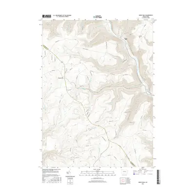
2016 Map of Jersey Mills
USGS Topo · Published 2016About this map
Pine Creek Gorge dominates the eastern edge of this landscape, carving a deep corridor through the high plateaus of Clinton Co and Lycoming Co. The small settlement of Jersey Mills sits along the creek's bank, while the high-altitude crossroads of Haneyville anchors the western side of the sheet. The terrain between these points is defined by a dense network of watercourses and hollows, including Pine Hollow, Gorman Draft, and the various branches of Ott Fork. This area is marked by a legacy of transport and access, traced through the Old Coudersport Pike in the south and numerous named forest routes like Sinking Springs RD and Browns Run RD. The map reveals a heavily dissected topography where ridges like Huntley Mtn separate drainage systems such as McClure Run and Solomon Run, illustrating the intricate natural drainage patterns that have shaped the region's development and trail networks.
Find a feature on this map
68 named features on this map. Tap any name to fly to it.
Don’t see what you’re looking for? This feature index may not catch every label — zoom into the map to look around manually.
Map Details
Editions of this 2016 Jersey Mills Map
This is the sole edition of this map. No revisions or reprints were ever made.
Other maps of this area

1921 · Howard
USGS Topo · 1:48,000

1921 · Lock Haven
USGS Topo · 1:62,500

1923 · Howard
USGS Topo · 1:62,500

1923 · Lock Haven
USGS Topo · 1:62,500

1935 · Waterville
USGS Topo · 1:24,000

1937 · Waterville
USGS Topo · 1:48,000

1943 · Hyner
USGS Topo · 1:62,500

1943 · Waterville
USGS Topo · 1:62,500

1944 · Lock Haven
USGS Topo · 1:62,500

1946 · Renovo East
USGS Topo · 1:62,500
Featured Places
- Gallagher Township, PA
- Jersey Mills, McHenry Township
- Colebrook Township, PA
- McHenry Township, PA
- Watson Township, PA