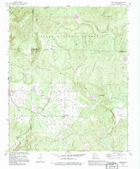
1990 Map of Jerusalem
USGS Topo · Published 1995About this map
Jerusalem stands as the central hub of this northern Conway County landscape, situated at a junction of roads where the southern foothills meet the edge of the Ozark National Forest. The map reveals a community defined by its proximity to natural resources and higher elevations, including the nearby Jerusalem Gas Field and the complex terrain of Kincannon Mountain. To the west and north, smaller settlements like Appleton and the high-altitude Stumptoe are connected by winding routes through areas like Grassy Gap.
Find a feature on this map
44 named features on this map. Tap any name to fly to it.
Don’t see what you’re looking for? This feature index may not catch every label — zoom into the map to look around manually.
Map Details
Editions of this 1990 Jerusalem Map
This is the sole edition of this map. No revisions or reprints were ever made.
Other maps of this area

1879 · Washington
USGS Topo · 1:62,500

1887 · Smyrna
USGS Topo · 1:62,500

1889 · Marshall #3
USGS Topo · 1:62,500

1892 · Marshall
USGS Topo · 1:125,000

1892 · Morrillton
USGS Topo · 1:125,000

1894 · Morrillton
USGS Topo · 1:125,000

1894 · Marshall
USGS Topo · 1:125,000

1901 · Marshall
USGS Topo · 1:125,000
1940 · Smyrna
USGS Topo · 1:62,500

1943 · Smyrna
USGS Topo · 1:62,500