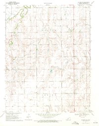
1970 Map of Jetmore NW
USGS Topo · Published 1971About this map
Pawnee River winds through the northern reaches of this Hodgeman County landscape, carving a valley that stands in contrast to the surrounding upland plains. During the late 1960s, this area was defined by a mix of traditional agriculture and a growing petroleum industry, evidenced by the extensive Oil Field and the specific Goebel East Oil Field developments. Small-scale resource extraction is visible through localized features such as a Quarry and Sandpit, while an underground Pipeline cuts across the terrain to transport the region's energy output. The presence of numerous Drill Holes reflects active exploration during this period. Away from the river, drainage is managed by seasonal waterways like Cottonwood Creek and the aptly named Dry Creek, which help define the contours of the Valley and Center townships.
Find a feature on this map
13 named features on this map. Tap any name to fly to it.
Don’t see what you’re looking for? This feature index may not catch every label — zoom into the map to look around manually.
Map Details
Editions of this 1970 Jetmore NW Map
This is the sole edition of this map. No revisions or reprints were ever made.
Other maps of this area

1892 · Ness
USGS Topo · 1:125,000

1894 · Ness
USGS Topo · 1:125,000

1955 · Great Bend
USGS Topo · 1:250,000

1955 · Scott City
USGS Topo · 1:250,000

1957 · Great Bend
USGS Topo · 1:250,000

1958 · Great Bend
USGS Topo · 1:250,000

1958 · Scott City
USGS Topo · 1:250,000

1969 · Jetmore
USGS Topo · 1:24,000

1970 · Jetmore SE
USGS Topo · 1:24,000

1970 · Jetmore NE
USGS Topo · 1:24,000