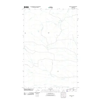
2011 Map of Jiggs Flat
USGS Topo · Published 2011About this map
Jiggs Flat serves as the central point of this high-plains landscape in Chouteau County, where the terrain is defined by a dendritic network of seasonal and permanent watercourses. The local topography is punctuated by prominent landmarks such as Round Butte and the Libby Hills, providing essential orientation points in an otherwise expansive grassland. The drainage patterns of Cottonwood Creek, Cowboy Creek, and Fall Creek illustrate the natural watershed of the region, while County Rd-201 provides the primary arterial access across the southern portion of the quadrangle. This 2011 survey captures the spatial relationship between these water sources and the cattle-grazing territory of North Central Montana, revealing the enduring layout of rural ranching infrastructure.
Find a feature on this map
10 named features on this map. Tap any name to fly to it.
Don’t see what you’re looking for? This feature index may not catch every label — zoom into the map to look around manually.
Map Details
Editions of this 2011 Jiggs Flat Map
This is the sole edition of this map. No revisions or reprints were ever made.
Other maps of this area

1890 · Fort Benton
USGS Topo · 1:250,000

1892 · Fort Benton
USGS Topo · 1:250,000

1897 · Fort Benton
USGS Topo · 1:250,000

1954 · Great Falls
USGS Topo · 1:250,000

1957 · Great Falls
USGS Topo · 1:250,000

1972 · Square Butte
USGS Topo · 1:24,000

1978 · Leiberg Coulee
USGS Topo · 1:24,000
1978 · Geraldine
USGS Topo · 1:24,000
1979 · Palisade Butte
USGS Topo · 1:24,000
1979 · Jiggs Flat
USGS Topo · 1:24,000