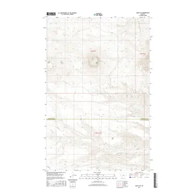
2017 Map of Jiggs Flat
USGS Topo · Published 2017About this map
Round Butte rises as the central landmark of this High Plains landscape, situated along the county line between Chouteau and Judith Basin Counties. The terrain is defined by a series of drainage systems, including Willow Creek and Cowboy Creek, which cut through the open country. To the west, the Libby Hills and Ole Coulee provide topographic relief, while the southern portion of the map levels out into the expanse of Jiggs Flat. This 2017 survey reveals a sparsely populated ranching or agricultural region where movement is dictated by a few rural routes like County Road 201 and Spencer Road. The intricate network of seasonal waterways, such as Cottonwood Creek and Fall Creek, illustrates the essential relationship between water and land use in this part of Montana.
Find a feature on this map
17 named features on this map. Tap any name to fly to it.
Don’t see what you’re looking for? This feature index may not catch every label — zoom into the map to look around manually.
Map Details
Editions of this 2017 Jiggs Flat Map
This is the sole edition of this map. No revisions or reprints were ever made.
Other maps of this area

1890 · Fort Benton
USGS Topo · 1:250,000

1892 · Fort Benton
USGS Topo · 1:250,000

1897 · Fort Benton
USGS Topo · 1:250,000

1954 · Great Falls
USGS Topo · 1:250,000

1957 · Great Falls
USGS Topo · 1:250,000

1972 · Square Butte
USGS Topo · 1:24,000

1978 · Leiberg Coulee
USGS Topo · 1:24,000
1978 · Geraldine
USGS Topo · 1:24,000
1979 · Palisade Butte
USGS Topo · 1:24,000
1979 · Jiggs Flat
USGS Topo · 1:24,000