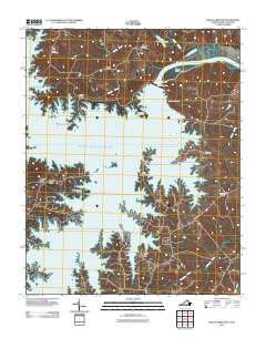
2011 Map of John H Kerr Dam
USGS Topo · Published 2011About this map
John H Kerr Dam controls the flow of the Roanoke River at the Virginia and North Carolina border, creating the sprawling finger-like reaches of the John H. Kerr Reservoir. This 2011 survey illustrates the complex shoreline of the reservoir, highlighting geographic features like Keats Peninsula, Buggs Island, and Gilligans Island. The map documents established communities and residential pockets such as Castle Heights, Rose Hill, and Phillis, providing a precise look at the modern road network and lake access points like North Bend Park Marina. Genealogists will find the locations of Shiloh Cemetery, Bethesda Cemetery, and Union Chapel Cemetery particularly valuable, as these sites often predate the massive hydrological changes brought by the dam's construction.
Find a feature on this map
30 named features on this map. Tap any name to fly to it.
Don’t see what you’re looking for? This feature index may not catch every label — zoom into the map to look around manually.
Map Details
Editions of this 2011 John H Kerr Dam Map
This is the sole edition of this map. No revisions or reprints were ever made.
Other maps of this area

1953 · Greensboro
USGS Topo · 1:250,000

1954 · Greensboro
USGS Topo · 1:250,000

1955 · Boydton
USGS Topo · 1:62,500

1962 · Greensboro
USGS Topo · 1:250,000

1966 · Greensboro
USGS Topo · 1:250,000

1968 · Bracey
USGS Topo · 1:24,000
1968 · Tungsten
USGS Topo · 1:24,000

1968 · John H Kerr Dam
USGS Topo · 1:24,000
1968 · Boydton
USGS Topo · 1:24,000
1968 · Baskerville
USGS Topo · 1:24,000