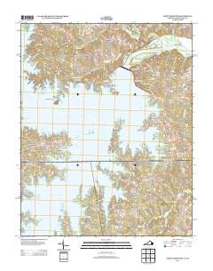
2013 Map of John H Kerr Dam
USGS Topo · Published 2013About this map
The John H Kerr Dam stands as the central engineering feat of this landscape, managing the transition from the expansive John H. Kerr Reservoir into Lake Gaston. This 2013 survey illustrates the modern topography of the Virginia-North Carolina border, where the flooding of the Roanoke River valley has created a complex shoreline of peninsulas like Keats Peninsula and Presbyterian Point. Scattered settlements such as Castle Heights, Phillis, and Rose Hill occupy the higher ground above the inlets. The map details a recreation-oriented economy defined by access points like North Bend Park Marina and Eastland Creek Landing, alongside residential developments such as Cusco Willa. Small tributaries, including Robbins Cr and Ellington Br, carve into the surrounding woodland, feeding the massive reservoir system that dominates the region's geography.
Find a feature on this map
90 named features on this map. Tap any name to fly to it.
Don’t see what you’re looking for? This feature index may not catch every label — zoom into the map to look around manually.
Map Details
Editions of this 2013 John H Kerr Dam Map
This is the sole edition of this map. No revisions or reprints were ever made.
Other maps of this area

1953 · Greensboro
USGS Topo · 1:250,000

1954 · Greensboro
USGS Topo · 1:250,000

1955 · Boydton
USGS Topo · 1:62,500

1962 · Greensboro
USGS Topo · 1:250,000

1966 · Greensboro
USGS Topo · 1:250,000

1968 · Bracey
USGS Topo · 1:24,000
1968 · Tungsten
USGS Topo · 1:24,000

1968 · John H Kerr Dam
USGS Topo · 1:24,000
1968 · Boydton
USGS Topo · 1:24,000
1968 · Baskerville
USGS Topo · 1:24,000