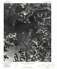
1977 Map of John H Kerr Dam
USGS Topo · Published 1978About this map
The John H Kerr Dam stands as the central engineering feature of this landscape, anchoring the massive John H Kerr Reservoir along the border of Virginia and North Carolina. This orthophotograph, prepared from 1977 aerial imagery by the U.S. Geological Survey and the Soil Conservation Service, provides a high-contrast visual record of the intricate shoreline and the surrounding agricultural tracts. To the south, the Roanoke River feeds into Lake Gaston, while the wooded and cleared lands of the Rose Hill area reveal the land-use patterns of the late 1970s. The map captures a moment before further shoreline development, showing the transition from riverine flow to controlled reservoir levels in Mecklenburg County.
Find a feature on this map
5 named features on this map. Tap any name to fly to it.
Don’t see what you’re looking for? This feature index may not catch every label — zoom into the map to look around manually.
Map Details
Editions of this 1977 John H Kerr Dam Map
This is the sole edition of this map. No revisions or reprints were ever made.
Other maps of this area

1953 · Greensboro
USGS Topo · 1:250,000

1954 · Greensboro
USGS Topo · 1:250,000

1955 · Boydton
USGS Topo · 1:62,500

1962 · Greensboro
USGS Topo · 1:250,000

1966 · Greensboro
USGS Topo · 1:250,000

1968 · Bracey
USGS Topo · 1:24,000
1968 · Tungsten
USGS Topo · 1:24,000

1968 · John H Kerr Dam
USGS Topo · 1:24,000
1968 · Boydton
USGS Topo · 1:24,000
1968 · Baskerville
USGS Topo · 1:24,000