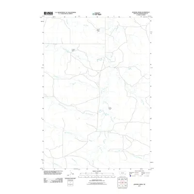
2011 Map of Johnnie Creek
USGS Topo · Published 2011About this map
Mizpah Creek and its many winding tributaries dominate this drainage landscape in Powder River County, Montana. The map illustrates a ranching and water-management system defined by several small reservoirs, including the Russiff Number 1 Dam, J Janssen Number 1 Dam, and A Irion Number 1 Dam. These features, alongside named drainages such as Lost Soldier Creek and Mud Spring Creek, reveal the importance of seasonal water sources in this arid part of the state. The infrastructure is minimal, consisting primarily of unpaved routes like Hay Creek Rd and Mizpah Rd that follow the natural contours of the land. This survey provides a clear view of the rural topography before further modernization, focusing on the essential relationship between the land and the waterways like Johnnie Creek that give the area its name.
Find a feature on this map
15 named features on this map. Tap any name to fly to it.
Don’t see what you’re looking for? This feature index may not catch every label — zoom into the map to look around manually.
Map Details
Editions of this 2011 Johnnie Creek Map
This is the sole edition of this map. No revisions or reprints were ever made.
Other maps of this area

1954 · Ekalaka
USGS Topo · 1:250,000

1956 · Ekalaka
USGS Topo · 1:250,000

1958 · Ekalaka
USGS Topo · 1:250,000

1965 · Ekalaka
USGS Topo · 1:250,000

1973 · Olive
USGS Topo · 1:24,000

1973 · Cross S School
USGS Topo · 1:24,000
1973 · Witcher Reservoir
USGS Topo · 1:24,000

1973 · Moonlight Creek
USGS Topo · 1:24,000

1973 · Coalwood
USGS Topo · 1:24,000
1973 · Rattlesnake Hill
USGS Topo · 1:24,000