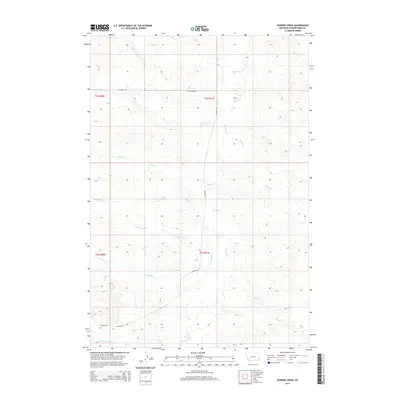
2014 Map of Johnnie Creek
USGS Topo · Published 2014About this map
Mizpah Cr forms the primary drainage through this section of Powder River County, weaving a complex hydrological network alongside Johnnie Cr and Lost Soldier Cr. The terrain is defined by its seasonal watercourses, including smaller branches like Mud Spring Cr and Sheep Cr, which dictate the sparse transportation corridors of the region. The map reveals the layout of rural access points such as Hay Creek Rd and Mizpah Rd, providing a clear look at the Public Land Survey System divisions between T1S and T2S. These townships, characterized by cattle ranching infrastructure and intermittent stream beds like Double Corral Cr, represent the enduring character of the Montana plains in the early twenty-first century.
Find a feature on this map
17 named features on this map. Tap any name to fly to it.
Don’t see what you’re looking for? This feature index may not catch every label — zoom into the map to look around manually.
Map Details
Editions of this 2014 Johnnie Creek Map
This is the sole edition of this map. No revisions or reprints were ever made.
Other maps of this area

1954 · Ekalaka
USGS Topo · 1:250,000

1956 · Ekalaka
USGS Topo · 1:250,000

1958 · Ekalaka
USGS Topo · 1:250,000

1965 · Ekalaka
USGS Topo · 1:250,000

1973 · Olive
USGS Topo · 1:24,000

1973 · Cross S School
USGS Topo · 1:24,000
1973 · Witcher Reservoir
USGS Topo · 1:24,000

1973 · Moonlight Creek
USGS Topo · 1:24,000

1973 · Coalwood
USGS Topo · 1:24,000
1973 · Rattlesnake Hill
USGS Topo · 1:24,000