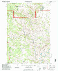
1995 Map of Johnny Cake Mountain
USGS Topo · Published 1998About this map
Johnny Cake Mountain rises as a prominent landmark in this mid-1990s survey of the high country along the Morrow Co Grant Co border. Located largely within the Umatilla National Forest, the terrain is defined by a dense network of water sources and steep drainages, including the aptly named Mulligan Stew Creek and Skookum Creek. The remote settlement of Loulatt sits near the western edge, while numerous named springs like Buckhorn Spring and Tonto Spring indicate a landscape where water management was critical for both forest ecology and historical range use. In the southern reach of the map, the North Fork John Day River carves through the canyon floor, accessed by a footbridge and surrounded by named topographic features such as Neal Butte and Mahogany Flat. This area illustrates the complex drainage systems of the Blue Mountains, where Little Wall Creek and Big Wall Creek converge toward the river system.
Find a feature on this map
29 named features on this map. Tap any name to fly to it.
Don’t see what you’re looking for? This feature index may not catch every label — zoom into the map to look around manually.
Map Details
Editions of this 1995 Johnny Cake Mountain Map
This is the sole edition of this map. No revisions or reprints were ever made.
Other maps of this area

1951 · Monument
USGS Topo · 1:62,500

1953 · Kimberly
USGS Topo · 1:62,500

1953 · Pendleton
USGS Topo · 1:250,000

1955 · Canyon City
USGS Topo · 1:250,000

1956 · Pendleton
USGS Topo · 1:250,000

1959 · Canyon City
USGS Topo · 1:250,000

1969 · Lake Penland
USGS Topo · 1:24,000

1969 · Madison Butte
USGS Topo · 1:24,000

1969 · Big Rock Flat
USGS Topo · 1:24,000

1980 · Monument
USGS Topo · 1:100,000