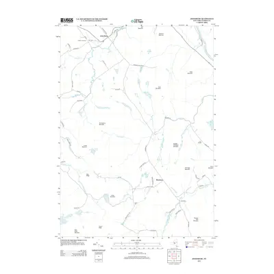
2013 Map of Johnsburg
USGS Topo · Published 2013About this map
Johnsburg and Thurman serve as the primary nodes of settlement in this northern New York landscape, situated within the protective boundaries of the Adirondack Park Preserve. The terrain is defined by a series of prominent peaks and ridges, including Crane Mountain, Huckleberry Mountain, and Wolf Pond Mountain, which dictate the winding paths of the local road network. For those tracing family histories, the map identifies small, localized sites such as Bates Cem near Gobbler's Knob Farm and Russell Cem further south. Water systems are integral to the area's layout, with the Hudson River touching the northeastern corner while internal drainage is managed by a network of brooks and creeks, notably Glen Cr and Patterson Brook. The presence of Camp Dippikill and several remote ponds like Snowshoe Pond and Crane Mountain Pond indicates a land primarily utilized for conservation, recreation, and small-scale agriculture.
Find a feature on this map
66 named features on this map. Tap any name to fly to it.
Don’t see what you’re looking for? This feature index may not catch every label — zoom into the map to look around manually.
Map Details
Editions of this 2013 Johnsburg Map
This is the sole edition of this map. No revisions or reprints were ever made.
Other maps of this area

1895 · North Creek
USGS Topo · 1:62,500

1897 · North Creek
USGS Topo · 1:62,500

1898 · Thirteenth Lake
USGS Topo · 1:62,500

1903 · Luzerne
USGS Topo · 1:62,500

1910 · Stony Creek
USGS Topo · 1:62,500

1950 · Glens Falls
USGS Topo · 1:250,000

1950 · Utica
USGS Topo · 1:250,000

1954 · Thirteenth Lake
USGS Topo · 1:62,500

1954 · Harrisburg
USGS Topo · 1:62,500
1955 · Lake Luzerne
USGS Topo · 1:62,500