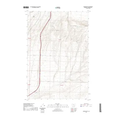
2020 Map of Johnson Butte
USGS Topo · Published 2020About this map
Horse Heaven Hills rise above a landscape of deeply cut drainages in this Benton County survey. The prominence of Johnson Butte serves as a central landmark for the surrounding terrain, which is defined by a series of significant canyons including Amon Canyon, Zintel Canyon, and Bofer Canyon. This modern topographic study reveals a sparse, high-country road network typical of the Columbia Plateau's agricultural and grazing lands. A series of thoroughfares, such as Coffin Rd, Beck Rd, and Bofer Canyon Rd, connect the high ridges to the lowland passes. The presence of the named locality Jump Off Joe along Jump Off Joe Rd reflects the local vernacular and long-standing nomenclature of this upland region.
Find a feature on this map
16 named features on this map. Tap any name to fly to it.
Don’t see what you’re looking for? This feature index may not catch every label — zoom into the map to look around manually.
Map Details
Editions of this 2020 Johnson Butte Map
This is the sole edition of this map. No revisions or reprints were ever made.
Other maps of this area

1908 · Umatilla
USGS Topo · 1:125,000

1917 · Pasco
USGS Topo · 1:125,000

1953 · Pendleton
USGS Topo · 1:250,000

1953 · Walla Walla
USGS Topo · 1:250,000

1956 · Pendleton
USGS Topo · 1:250,000

1958 · Walla Walla
USGS Topo · 1:250,000

1962 · Hat Rock
USGS Topo · 1:24,000

1962 · Juniper
USGS Topo · 1:24,000

1962 · Umatilla
USGS Topo · 1:24,000
1964 · Johnson Butte
USGS Topo · 1:24,000